Friday, April 10, 2015

Week 12: Stereoscope

The focus for class this week was on stereoscopes and their use for interpreting aerial images.  A stereoscope is a device that has two optical lenses that allow people to see depth and three dimensions in two dimensional pictures.  It does not work for any ordinary picture. Two pictures are mounted together side by side. Both pictures have the same image but from two different viewpoints.  The picture on the left would represent what the left eye would see and the picture on the right would represent what the right eye would see.  This makes it possible for the two images to come together as one image when looking through the lenses of the stereoscope.  It was most commonly used in the entertainment industry and for military purposes.  

I was lucky enough to get the opportunity to use vintage U.S. Army pocket stereoscopes in class this week.  Dr. Suresh brought in a bunch of pocket stereoscopes and aerial images of interesting landscapes to view.  At first a lot of people including myself were having trouble viewing the images. It takes some time to find the right viewing distance and focus your vision properly to see one 3-D image. Below are some pictures I took in class while we were using the stereoscopes.


I studied five black and white pictures using the stereoscope.  One was of the Sacaton Mountains in west central Arizona.  This was the first one I studied and I could barely make out what anything was in the picture by looking at it with a naked eye. But using the stereoscope everything changes and I saw peaks of mountains being raised out of the picture.  There was a river running through the landscape in the valleys of the mountains.  However, the mountains were by them self and not really apart of a mountain range. They were surrounded by what seemed like fairly level land.

Another picture was of Inselberge in southeastern California.  This picture was similar to the last with the raised mountains.  These mountains appeared to be more massive. The surrounding landscape seemed to be of the same consistency and of smooth texture.  There was a wave-like flow to the area surrounding the mountains. I read later that this area is sediment and debris that is slowing passing through the mountains toward the Salton Sea. 

The third picture was of a place in Honolulu, Hawaii called Diamond Head. This picture had some smoother mountains and a large crater surrounded by civilization.  You could tell it was a civilization because of the straight lines (roads) that created tiny blocks where you could barely make out the structure of buildings.   The crater had a ridged circular rim around the smooth base.  

The picture of Rattlesnake Ridge in the Colorado Rocky Mountains had a lot of different textures in it. There appeared to be two long mountain ranges running across the picture with a valley in between them. The one mountain range had a repeating cut of different depth in the mountain.  Also the valley was of different colors and I saw smooth lines which I figured to be from farming. 

The last aerial image was of Longs Peak, the highest elevation in Rocky Mountain National Park, Colorado.  This one like some of the others showed large mountains raised form the pictures but these were more like a mountain range than the others.  There appeared to be less valleys and most of the landscape looked rough.  Also in all of the pictures you could see the shadows form the sun which helped me understand the different features in the image.  Now I can understand how valuable the stereoscope was in the World Wars for military intelligence to understand the magnitude of the landscape they were dealing with. 


http://www.jmu.edu/cisr/research/sic/rs/interpreting.htm

http://www.dlt.ncssm.edu/collections/toys/html/exhibit01.htm

Sunday, April 5, 2015

Week 11 Media Lab and Miscellaneous


This week there were no readings to comment on because the class is wrapping up one project and starting another.  It has been a busy week working on the aerial balloon project and gathering information for my final project that is about the use of remote sensing for mineral exploration.

On a side note, on Monday Dr. Suresh showed us rare footage of a specific species of bats mating that he was able to see in person during his field trip last week. I'm not an  expert on bats but he said it was extremely rare to witness such a thing.

On Wednesday, we held class in the media lab.  We had an informative tutorial on how to use different programs to make our video presentations for our final project.  The focus was on the video program, Premiere Pro.

The only other experience I have with making and editing videos was in eighth grade.  We used an outdated, limited, software program.  I wish had access to a program like Premiere Pro back then. When I opened up Premiere Pro at first it looked overwhelming but after toying with it a little bit I started to get the hang of it. Nick Wigelsworth and I worked together to complete the video below. We gathered a couple aerial images from NASA Earth and we explained the scientific and art aspects of each picture.  There are many effects you can add to the videos using Premiere Pro and in the video below we implemented the zoom in and zoom out effect.

Over the next few weeks I will be using this program a lot to create my project regarding mineral exploration and remote sensing.  I truly believe that having the skill set to make videos using Premiere Pro will be highly advantageous in the future.

Friday, March 27, 2015

Week 10: Controversies with UAVs

This week in class we learned about the current uses of drones, the technology behind them, and the social difficulties with drone usage. Now when the common public hears the word "drone" they usually associate it as a bad thing.  For example they think of the few instances where predator drones had a miss-fire and killed civilians in the Middle East.  However that really is the only time people hear the about drones on the media. Drones come in multiple shapes and sizes and they can be applied for various humane uses.

Some of the potential uses for drones is shipping products, traffic surveillance, natural disaster surveillance, and crop monitoring.  They can even be used for emergency situations such as house fires to find if anyone is left in the house what paths to take. There are many other uses waiting to be discovered but I believe the greatest potential lies in the light shipping industry and law enforcement.

I wouldn't be surprised if we see drones flying all over the tops of buildings in a few decades from now bringing people anything from their Cookout meals to their school books they bought of amazon.  It would probably be a lot more efficient too because the drones could take a shorter path to destination rather than following a road. Also, it could probably run on renewable energy such as solar power because in one of NOVA's documentary videos about drones they showed one of the military's drones that can stay in flight all day every day because of solar power. This could reduce the amount of harmful emissions that come from the trucks, planes, and postal cars.

The drones could also help out law enforcement substantially with surveillance but the common public would probably be against that. Yet at the same time I don't see what the problem with it is because law enforcement already uses helicopters for surveillance so I think they should be able to use the more efficient method by using drones.  There just has to be good regulations that does not violate our rights to privacy.

If the common person would like to fly a drone such as a quad-copter for recreational uses he/she would have to comply to the following regulations.

• "Follow community-based safety guidelines, as developed by organizations such as the Academy of Model Aeronautics.
• Fly no higher than 400 feet and remain below any surrounding obstacles when possible. 
• Keep your sUAS in eyesight at all times, and use an observer to assist if needed. 
• Remain well clear of and do not interfere with manned aircraft operations, and you must see and avoid other aircraft and obstacles at all times.
• Do not intentionally fly over unprotected persons or moving vehicles, and remain at least 25 feet away from individuals and vulnerable property. 
• Contact the airport or control tower before flying within five miles of an airport. 
• Do not fly in adverse weather conditions such as in high winds or reduced visibility. 
• Do not fly under the influence of alcohol or drugs. 
• Ensure the operating environment is safe and that the operator is competent and proficient in the operation of the sUAS. 
• Do not fly near or over sensitive infrastructure or property such as power stations, water treatment facilities, correctional facilities, heavily traveled roadways, government facilities, etc. 
• Check and follow all local laws and ordinances before flying over private property. 
• Do not conduct surveillance or photograph persons in areas where there is an expectation of privacy without the individual’s permission"
 (http://knowbeforeyoufly.org/wp-content/uploads/2015/01/KBYF_Brochure.pdf)

As you can see there are many regulations and rules about flying personal drones.  I think this long list is a smart way to make sure private drone usage is safe for the rest of the public. However, in order to allow the drone 


Quad-copter

www.x-sportsworld.com


Friday, March 20, 2015

Week 9: Balloon Aircraft Project and Unmanned Aerial Systems

After the spring break, this week in class we began to explore the history and development of the UAV. When people hear of unmanned aerial vehicles today they tend to think of drones and predator drones that are capable of taking down enemy targets.  UAVs were created primarily because since the Civil War and WWI  people saw the importance of having the intel of the geography/terrain and the enemy's movements.  As I have mentioned before, the United States saw the value of using balloon aircraft to gather intelligence in both the civil war and WWI. However, in WWII other countries especially France advanced from balloon aircraft to war planes.  This time period served more as an experimental phase for which air crafts worked well. For example they began to figure out what were the best uses for lighter planes and bigger heavier aircraft.  Even though light aircraft flew a quarter million missions in Europe during WWII  there were many accidents and malfunctions with the planes and missions.  One of the problems were that they were so massed produced in a short period of time which led to many problems.  For example, as a ship carried the planes over seas, some pilots and their crew would spend the whole time fixing all the planes manufacturing problems.
Even worse, in operation TORCH it was the Army's first use of light aviation in combat and it ended horrifically. It ended being shot down by friendlies due to the lack of communication.  However, in the coming wars (Cold War,Vietnam, Korean) the United States Air Force improved dramatically.  Along with helicopters and improved combat planes came the start of practical UAVs. At first they were used for observation purposes and target practice for the military.  Now, today there are a variety of uses for UAVs ranging from taking out enemies to gathering agricultural data. 

This week's reading has been somewhat of a review on everything we learned prior to spring break. It touched on the uses of balloon aircraft and the different techniques to acquiring observational data.  
Even though this reading was mostly about the use of air craft in the military, a lot of the same techniques and devices are used for commercial purposes. For example, some UAVs today have similar purposes as satellites and may be even more efficient in certain cases.  

I am looking forward to researching and providing more information about the current uses and controversies regarding drones.

Before I close this blog, I must give a shout out to the facilities people here at Furman University for retrieving the Go-Pro out of the tree for my group.  


https://furman.app.box.com/files/0/f/3275246380/1/f_27493411538


Thursday, March 5, 2015

Week 7: Light Spectrum

This week in class we discussed multiple topics relating to light waves and resolution in remote sensing.  We addressed some of the things that are a part of our everyday lives that we never really question the science behind. For example, why the sky is blue, why clouds are white/gray, and why the sunsets are a mix of the red, pink, and orange.  The reasoning behind it has to do with the wave length of light and light scattering. Since blue light in the visible spectrum has a short wavelength and high frequency it has a greater chance of colliding with other particles in the atmosphere and sent in another direction, which is called scattering. Most of blue light is scattered in the atmosphere which is why the sky appears blue during the day time. Now the reason why we have beautiful sunsets with the shades of red is because red light has a longer wavelength.  The longer wavelength means less chances of scattering and it travels a longer distance. So at dawn and dusk when our place on Earth's surface is far from the sun, you can think of it as a tangent point, the red, orange, and yellow light is visible.  Look at the picture below to see a visual explanation.


www.esrl.noaa.gov

This is a picture of a sunset I took this past Summer in Florence Italy.  
Taken by Stephen Barr in Florence

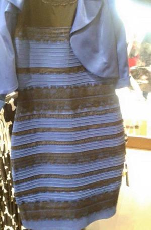
Another thing I have to mention is "the dress" because it became a phenomenon in just one day.  On Thursday, April 26th, my friend texted me a picture of this dress and she asked me, "Stephen, what color is this dress?" I thought it was a strange question to ask but I texted her back "blue and gold" and my friend, looking over my shoulder at my phone, saw the dress as gold and white and he was shocked at my text and asked me, "dude why did you say blue and black!?" From there it didn't take long to find out that this dress is playing tricks on us.  There are a lot of websites and blogs on the internet that try to explain it. Some of the theories are fictional for the most part, for example, one explanation tried to say that if you see black and blue and means you are feeling depressed. Another article went on to explain how humans never really saw "blue" until recently. Blue was just a shade of another color. They looked at old texts and artifacts and none mentioned blue. One of the examples they used in history is the book The Odyssey, the author, Homer, describes the color of the sea as "wine-dark."  I'm still not quite sure how that relates to people see different colors of the dress now.
Another source, Professor Billy Hammond from UGA believes the changes in color has to do with the opponent process theory. He says that the dress's color falls right at the intersection where we perceive one color as opposed to another.  That explanation makes a little more sense to me because it is strange how sometimes when I look at the dress, the color changes right before my eyes.  

Dress

I have to admit I find it really cool learning about the properties of light and why we see what we "see." For example on my trip to Chicago today, I understood why we saw haze in the sky and why the sunset was the color it was. It is neat seeing the world from the science perspective. 


http://www.businessinsider.com/what-is-blue-and-how-do-we-see-color-2015-2


http://www.redandblack.com/uganews/she-color-blinded-me-with-science-what-s-the-deal/article_8b90d15c-c1ea-11e4-b688-e703f9f523c4.html

Friday, February 20, 2015

Week 6: Vision and evolution of the Eye


This week's topics of discussion were by far the most intriguing to me.  We touched on the anatomy and physiology of the eye and the evolutionary aspects in the birds of paradise. This brought me back to the good memories of biology class in junior year of high school. Before I got into my thoughts about the birds of paradise in New Guinea, watch the videos below to have a better understanding of what I will be talking about.

 https://www.youtube.com/watch?v=W7QZnwKqopo

https://www.youtube.com/watch?v=YTR21os8gTA

As you can see, these birds have exotic practices to find a mate.  The males have all these extra
features on their body that seem to have no other function other than to attract a mate. Now the question is why would female birds find these exotic feature advantageous to reproduce with, such as the yellow poof or the long antenna like things in the picture below.


 https://www.youtube.com/watch?v=W7QZnwKqopo


http://ngm.nationalgeographic.com/2012/12/birds-of-paradise/laman-photography

The reason why it is so puzzling to scientists around the world is because of the natural selection process and evolution. The driving force of the way life came to be as it is today is natural selection and other factors of evolution.   Charles Darwin's idea of natural selection is the gradual process of having the  advantageous traits in a population be passed on and the disadvantageous traits become less common.  This happens through survival of the fittest, organisms with traits that help them survive and evade predators or disease will live to reproduce another generation. On the flip side, organisms within a species who have traits that are a disadvantage are usually more vulnerable to death and not being able to reproduce.

With that in mind, think back to the videos and the way that one bird cleared out a whole space on the ground to perform in mating dance.  In addition look at the pictures and notice that these birds are brightly colored and have these extra features that can get in the way of make them less agile. Now take in account their habitat, they live in tropical rain forests where the best protection from predators is to camouflage in the dense forest and these birds to the exact opposite. Their common predators include humans, snakes, and larger birds.  It puzzled me how these seemingly disadvantageous traits kept getting passed on until I found out that one possible explanation is that the females look for a lot of baggage and bright colors because if these birds can survive with the disadvantageous traits making them more susceptible to disease and predators then that means they must be quite resistant.

It is definitely an interesting way to look at it because it kind of goes against the traditional ideas of natural selection and survival of the fittest.  It shows that even if a bird has advantageous traits that make it camouflaged from predators and survives to live a good life, the traits will ultimately not be passed down to another generation if it can't find a mate.  This demonstrates the impact and importance of the female birds preferences in finding a mate.

http://a-z-animals.com/animals/birds-of-paradise/
http://evolution.berkeley.edu/evolibrary/article/evo_25

Friday, February 13, 2015

Week 5: Satellites


This week in class we learned about artificial satellites and their orbits. Most people know the basic idea that the artificial satellites revolve around the earth to provide us with things like Google Earth/Maps, GPS, and weather forecasts.  That is all the information I knew about satellites until this past week too. After reading some articles about satellites and their orbits I became very interested in the mechanics and uses of satellites because I realized how relevant and important they are to our daily lives here on Earth.  Therefore I researched three different satellites that have been launched since 2005; SMAP, MUOS 3, and the CZ-4B.

SMAP - Soil Moisture Active Passive, built by Jet Propulsion Labratory was launched by NASA with a Delta 2 rocket on January 31st, 2015.  This satellite has a 176 x 701 km x 98.1 deg parking orbit. Its orbit is near polar, sun synchronous, and travels from pole to pole in 98.5 min.  It has many purposes but the primary purpose is to measure the top 5cm of the earth's soil moisture and freeze/thaw states.  In addition, it will advance the accuracy behind short term weather forecasts, measure net carbon flux in boreal landscapes, drought monitoring, flood forecasting. The data collected from this satellite can address the problems in many other fields of study as well.
I am interested in hearing what the analysis on the threat of global warming comes back to be after the data has been collected.

Below are some pictures and videos related to SMAP.

NASA's SMAP launch

Below is a link to see the SMAP spacecraft seperation.
https://www.youtube.com/watch?v=lLY-w5wgPvw

MUOS 3 - Mobile User Objective System 3 was successfully launched January 20th, 2015 by United Launch Alliance's Atlas V rocket. This satellite's primary purpose is to improve ground communications of U.S forces around the world. This will allow better communication capability including simultaneous voice, video, and data using 3G technology.  I think this is much needed because communication is essential for military safety and the availability of communication in the middle-east and in foreign waters where most of our military forces are sent is very poor.

Below is a picture of the MUOS 3 launch.


YaoGan-5 a remote sensing satellite was launched by China via the Chang Zheng-4B in December 2008. From the information available, it is said that this satellite will be used for scientific research, land resources surveying, crop yield estimate and disaster prevention and relief. However, since little information has been released about this satellite and the fact that is a remote sensing and disaster relief satellite causes for skepticism about it's possible uses for military purposes.

Below is the picture of YaoGan-5 CZ-4B launch.


http://www.nasaspaceflight.com/2008/12/china-orbits-yaogan-5-via-chang-zheng-4b/
http://www.ulalaunch.com/ula-successfully-launches-navys-muos3.aspx?title=United+Launch+Alliance+Successfully+Launches+the+U.S.+Navy%E2%80%99s+Mobile+User+Objective+System-3
https://www.kennedyspacecenter.com/events/2015/january/launch-atlas5-muos3.aspx
http://hdl.handle.net/1721.1/87781
http://www.jpl.nasa.gov/news/news.php?feature=4471

Friday, February 6, 2015

Week 4: Cuban Missile Crisis

2/6/15

This week in class we read up on numerous articles involving the uses of aerial photography for military purposes.  Last week we left off at the uses of balloons and airships in the civil war and then about 50 years later WWI arrives and need for aerial photographs increases dramatically.  Especially towards the end of the war, 10440 photos were being examined by Allied interpreters in just a week. In total 6 million prints were produced on the Western Front during the war. Both sides saw the advantage of having access to what the enemy's latest movements were, and what their bases looked like.  Therefore, with this knowledge the officers in command could strategize accordingly before taking action.  On the other side, the countries with under developed imaging techniques were practically marching blindly into battle. The time period in history that interests me the most where aerial imaging was crucial is the Cuban Missile Crisis.

Tension began to escalate in the late 1950s and early 1960s between Russia and the United States primarily over Cuba and Communism.  Due to the Monroe Doctrine, the U.S. used to have the final say over some of the relations and policies of Latin American nations.  However, Fidel Castro begins his way to fame during the Cuban revolution in the 1950s. In 1959 Castro successfully overthrows Batista and establishes a new government with himself as Prime Minister.  In 1960, Castro meets with Soviet leaders and signs the Soviet-Cuban trade agreement. Cuba's new relation with the Soviet Union did not sit well with the U.S.  Over the year the U.S. trains and supplies Cuban exiles so try and take Castro out of power. These attempts end in multiples failures and Castro envelopes himself and Cuba in the Safety net of the Soviets (Roberts).

October 14th, 1962 becomes one of the big moments in history for aerial imaging.  On that day a U-2 surveillance plane flew over Cuba and some of the photographs captures nuclear-capable missile installations (Roberts).  I thought this was pretty interesting so I found some of the aerial photos of Cuba's missile installation bases and I pasted some of the clearer and focused pictures below. The thing I have trouble comprehending is how the interpreters were able to accurately justify that the pictures showed nuclear-capable missile installations. Without labels on the images I would have no idea what was featured in the photographs.  It must have been even more difficult for the interpreters because not only were the photographs in black and white but they probably haven't had any previous knowledge of what nuclear missiles looked like in photographs because they were new to this time period.  These interpreters were extremely skilled so see from a different dimension and valuable to have in the intelligence sector of the military.


Aerial Photograph of Missiles in Cuba (1962)

http://www.ourdocuments.gov/doc.php?doc=94

http://belfercenter.ksg.harvard.edu/files/09.24.12.%20kokoshin%20cmc%20paper%20FINAL%20COMBINED.pdf

Roberts, Priscilla Mary. Cuban Missile Crisis: The Essential Reference Guide. Santa Barbara, CA: ABC-CLIO, 2012. Print.

Week 3: Military Ballooons

1/30/15:

This week in my first year seminar class we researched and discussed the use of balloons for aerial imaging, especially its role in the military. Before this week, if anyone asked me if balloons were used in the civil war or world war one I would probably answer "no way." It is truly amazing to read how braze some of these individuals were that volunteered to go up in the balloon first or to test out parachuting from the balloon. Even after almost a century of innovations and safety guidelines applied to parachuting I am still not sure I would feel comfortable skydiving.

I am just shocked that anyone would come within a radius of the balloons they used back then because it is easily comparable to a floating bomb.  These balloons were filled up with hydrogen gas and if you are not familiar with hydrogen gas, it is very explosive.  Professor Thaddeus S.C. Lowe was the mastermind behind ballooning in the civil war and really made it possible to use them in battle.  He created the portable gas generator which then led to ground crews hauling from site to site. Lucky for the balloon crew, the guns of the civil war did not have the ability to reach the balloon when it was high above the battle field.  But it was not so much the same story for the balloon crews in World War I.  In WWI the enemy weaponry were powerful and accurate enough to reach the balloon at times and yet the balloons were still filled with highly flammable hydrogen gas. They made some renovations since the civil war such as a parachute for the trained balloon pilots but it was just as hazardous.  For example, there was an incident when the ground crew was anchoring the balloon down by rope and sandbags.  As one of the crew members was tying it down the static electricity from his hands rubbing the rope caused the whole balloon to ignite. This accident killed one and injured a few others. I know it is very important to gather the information and locations of enemy lines and bases but I don't think it was a smart move to use the military balloons they had for WWI.

The ideas and innovations made by Lowe and the other balloon engineers were new and impressive but the reliance on hydrogen gas was a big safety issue. If someone tried to make similar balloon today they would surely be arrested for a possible terrorist threat. Thankfully, today our hot air balloons rely on the principles of buoyancy and are not filled with just hydrogen gas.

Thursday, January 22, 2015

Week 2: Aerial Imaging and Fuse Timers

1/21/15:

After reading the Hemphill Changing Times article about the history of aerial imaging I was wondering how Batut would make the camera take a picture at the right time for his aerial images via balloon. The reading mentioned that in 1889 Arthur Batut published a whole book on how to use fuse timers for aerial imaging with kites. I would like to read up on that more and see the logistics behind it. Not only are those fuse timers helpful for aerial imaging for environmental science purposes and military intelligence, but it also probably helped out with the diffusion of stationary bombs and explosives for war purposes. I am familiar with how the simple wick fuse works with fireworks but I'm not sure how it would work with a camera.

After reading up on Batut's method a timer to take a picture I realized my conceptions of modern cameras interfered with my ability to think how he used a wick fuse to take a picture.  Back then the cameras used film. What I believe happened according to the readings is that a shutter blocked all light from entering the lens and film of the camera.  Then once the wick burned up after a couple minutes the shutter was released from the lens and the light was able to enter the film.  That makes a lot more sense than having a burning wick somehow push a button on a camera.

After some more research from  http://www.geog.ucsb.edu/~jeff/115a/history/kiteremotesensing.html  I was able to clarify the method behind the fuse timer. Batut used a slow burning fuse that he had lit prior to sending the kite off. In addition, he manufactured the kite in such a way so that when the fuse burned up, it triggered the shutter to be released, the image was then captured onto the film and a white paper slip was ejected so he knew when to pull the kite back down to the ground.  I find it very fascinating how he managed to get all the logistics right. He even predetermined the time it would take for the wick to burn up so that in the last seconds he would move with the directions of the wind so the kite would be more stable for a successful picture.  I find this very fascinating how he was that creative and able to successfully take an aerial photograph in his time period.


http://arch.ced.berkeley.edu/kap/background/history1.html